Business Intelligence technology (and in particular Location Intelligence) is key in the context of making the right business decisions. If in your company you determine, for example, the target group of marketing activities, study purchasing trends, or want to increase the predictive power of scoring models – consider enriching the already existing database with additional data.
The unveiled potential of enriching data with additional information
The development of modern technologies in the field of Data Science would not be so fast if it were not for the significant increase in the availability of data that now describes every aspect of life – both in the private and business spheres. From customer behavior data on websites, through sales data and product data, to data about a customer’s credit history, insurance history, or bank account balance… Both these and many other data are used to build predictive models concerning, for example, credit risk or recommendation of products with the highest probability of being purchased by a customer. Everything is done using machine learning technology. Until now, these models have made little use of location data such as a home address in geographic space. However, the pace of development of Location Intelligence technology indicates that the potential of supplementing the models built with information about a location or its environment has been recognized – and is increasingly used. This is because the location has tremendous predictive power. It affects characteristics such as credit risk, property value, default rates, wages, buying trends… and many others.
Next to geocoding, the key functionality of AlgoMaps LI is enriching address data with features of a given location (usually an address) or its closest surroundings. The set of features that can be added is very broad and amounts to about 1600! It is impossible to describe them all in detail, so we will divide them into broader categories:
- Know your customer with additional location and identification data
In this category, we distinguish additional information locating the address in geographical space – these are names of provinces, counties, and communes, but also less associated statistical regions and census districts, which are ideal for segmentation of customers according to geographical criteria. Additionally, we supplement all these entities (as well as street names) with unique TERYT identifiers that allow for the unambiguous recording of address information. - Use the exact building data
Within this category, information about the type of area where the building is located (city, village, suburban area, etc.) is distinguished. Information such as:
type of building (single-family or multi-family?),- number of dwellings,
- number of occupied apartments,
- number of inhabitants according to Central Statistical Office,
- number of persons registered according to identification numbers,
- number of dwellings where at least one person is registered according to identification numbers,
- number of companies, e.g., partnerships and sole proprietorships registered in the building.
- Consider the demographic structure of building inhabitants
In this case, detailed information about people living in the building are distinguished – i.e., number of women, number of men, as well as number of people by sex and 5-year age groups, i.e., number of women aged 25-30, number of men aged 35-40, etc. Benefit from this knowledge not only in terms of scoring but also to assure yourself targeted campaigns conversions. - Gain spatial data on the address environment
This is the broadest category, which contains about 1500 features that characterize the immediate surroundings of a location. The following data are distinguished:
- number of points of interest within 1 km of the building, e.g., stores, parks, schools, kindergartens, cafes, cinemas, theaters, pharmacies, supermarkets, hairdressers, etc;
- number and area of buildings of different types, e.g., residential, commercial, office, etc;
- number and length of roads of different types, e.g., freeways, expressways, road junctions, cycle paths, etc;
- number and area of different types of land types, e.g., forests, industrial land, residential land, commercial land, etc;
- number, length, and area of facilities related to public transport, e.g., streetcar and bus stops, train stations, metro stations, etc.
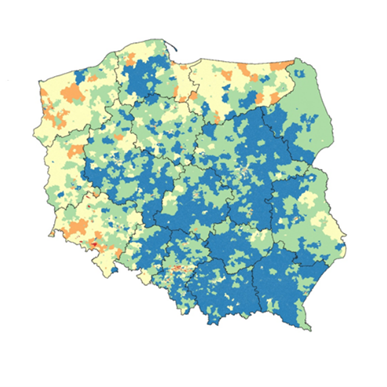
The use of these data is ideally suited to perform spatial analysis using Location Intelligence technology. They can also complement existing ML models, significantly increasing their predictive power and facilitating business decisions. These data can also be used to create spatial scoring concerning credit risk or default level. An example of such scoring is presented in the figure below.
Converting an address into spatial data and determining the distance in a straight line
Yet another type of data can be obtained using another Location Intelligence functionality – the ability to determine the length of distance that must be overcome between two points. With this functionality, we can determine, for example, how many potential customers live within a given distance from our distribution network. It is also important to determine the area, which is located at, for example, 10 minutes by car (the border of such an area is called an isochrone). Depending on the need, this information can feed predictive models or be used for LI analyses, and then make the right business decisions (such as opening a new store, an ATM, or a customer point placement). The AlgoMaps distance determination service accepts both addresses and geographic coordinates as input – a combination of both location methods is also possible. It is important because no prior knowledge of geographic coordinates is required, and the process of converting the address into spatial data is performed as the first stage of the solution. Moreover, the distance determination service, in addition to the information about the length of the road, also returns the distance in a straight line between points, which allows for the determination of the road complexity factor. This in turn can help to clarify the hitherto uncovered information scope of the ML model.
What do you and your business gain through data enrichment?
Properly standardized, complete data support the achievement of your business goals. By enriching the information in your database:
- You will perform precise spatial scoring (risk, propensity, property value);
- Segmentation of customers according to spatial/geographic criteria;
- Define the target group for your marketing activities;
- Get to know better the needs of your customers;;
- Obtain the best data on the market for geomarketing analysis;
- Obtain the correct business interpretation of data-based analyses;
- Complement ML models with spatial data that has high predictive power.
How to boost your business operations with AlgoMaps data enrichment?
As with the other services, there are two options here as well:
- Integration via WebService/API – you get access to additional location data, building data, the demographic structure of building occupants, and distance determination along roads
- Using an online application in the cloud – you get access to the previously described data including data on the surroundings of the address
By integrating with AlgoMaps via API, you get access to all the previously described services (standardization, geocoding, and autocomplete) and data enrichment – once you create a free account. You can also test some of the functionalities yourself, with a demo. The detailed operation of the service is described in the documentation, which allows you quick implementation.
The online application AlgoMaps is especially useful if you want to enrich the data of many addresses simultaneously. It is enough to prepare address data in a CSV file, define tasks and download the results. The whole process is intuitive and described in detail in the documentation. In addition to enrichment, you can also standardize and geocode data in the application.
Well, no matter how you use the app, you always get 1000 free records to process in AlgoMaps!
And that is not the end of AlgoMaps’ capabilities! In the next episode of the series, you will find out how to use Location Intelligence technology without having your own data.
Stay tuned!